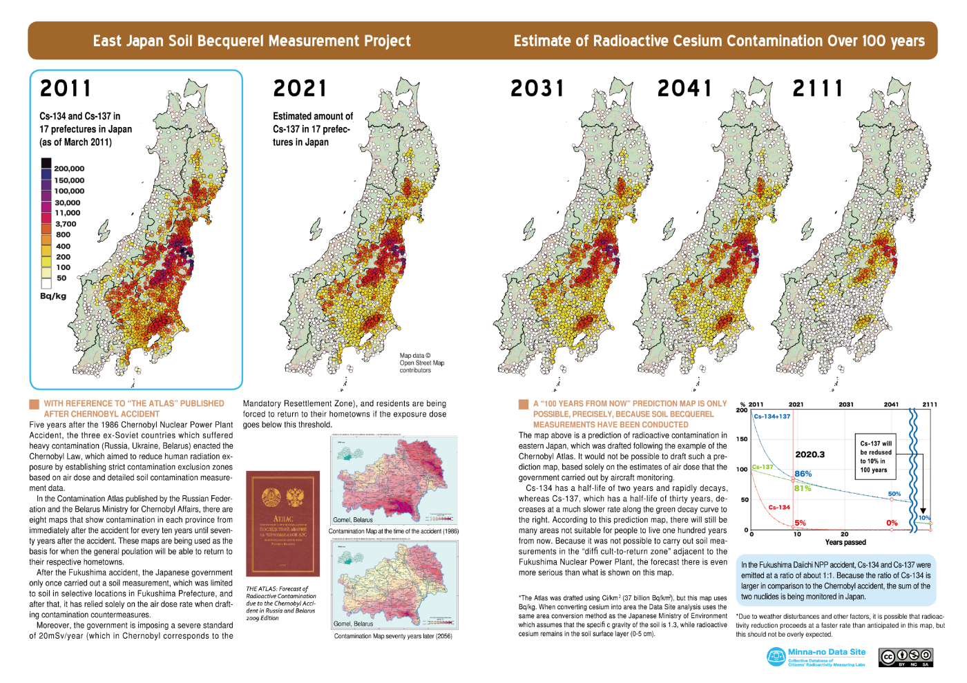
The Hazards of Tritium via ianfairlie.org

March 13, 2020

Summary

Nuclear facilities emit very large amounts of tritium, 3H, the radioactive isotope of hydrogen.  Much evidence from cell/animal studies and radiation biology theory indicates that tritium is more hazardous than gamma rays and most X-rays. However the International Commission on Radiological Protection (ICRP) continues to underestimate tritium’s hazard by recommending  a radiation weighting factor (wR) of unity for tritium’s beta particle emissions.  Tritium’s exceptionally high molecular exchange rate with hydrogen atoms on adjacent molecules makes it extremely mobile in the environment. This plus the fact that the most common form of tritium is water, ie radioactive water, means that, when tritium is emitted from nuclear facilities, it rapidly contaminates all biota in adjacent areas. Tritium binds with organic matter to form organically bound tritium (OBT) with long residence times in tissues and organs making it more radiotoxic than tritiated water (HTO). Epidemiology studies indicate increases in cancers and congenital malformations near nuclear facilities. It is recommended that nuclear operators and scientists should be properly informed about tritium’s hazards; that tritium’s safety factors should be strengthened; and that a hazard scheme for common radionuclides be established.

[…]

However there is a serious problem here. If similarly increased health effects had been observed near, say, a lead smelting factory or an asbestos mine, would they be dismissed by referring to these rationales? I rather doubt it. In other words, what is occurring here is that hidden biases in favour of nuclear power are in play. In my view, such conflicts of bias should be declared at the outset just as conflicts of interest are nowadays.

The Abuse of Statistical Significance Tests

Many epi studies of cancer near NPPs have found increased risks but dismissed them as not “statistically significant”. This wording often misleads lay readers into thinking that a reported increase is unimportant or irrelevant. But, in statistics, the adjective “significant” is a specialist word used to convey a narrow meaning, ie that the likelihood of an observation being a fluke is less than 5% (assuming a p = 5% test were used). It does not mean important or relevant.

The misuse of statistical significance is an important issue for four reasons. First, because the use of statistical significance tests has often led to the wrong result, especially in clinical trials, and the same is true in epidemiology studies in my experience. Several authrs have reported that the rejection of findings for significance reasons can often hide real risks (Axelson, 2004; Whitley and Ball, 2002).

Second, as Nature states “the rigid focus on statistical significance encourages researchers to choose data and methods that .. .yield statistical non-significance for an undesired result, such as potential side effects of drugs — thereby invalidating conclusions.” This damning verdict applies with equal force to the undesired result of observed increases in health effects in an epidemiology study. For decades, some scientists, sadly including those employed at UK government agencies, have dismissed risk findings in epidemiology studies near nuclear facilities by concluding they showed no “significant” raised risks or that excess risks were “not significant”, or similar phrases.

A third reason also mentioned in the Nature article, is that we must re-examine past studies which used lack of statistical significance to dismiss observed increases as these conclusions are now unreliable. This verdict applies, for example, to past studies by the UK Government’s Committee on the Medical Aspects of Radiation in the Environment (COMARE) studies which observed leukemia increases near UK nuclear facilities but dismissed them because they were not statistically significant. These include, for example,

COMARE (2011) Committee on Medical Aspects of Radiation in the Environment Fourteenth Report. Further Consideration of the Incidence of Childhood Leukaemia Around Nuclear Power Plants in Great Britain. HMSO: London.

[…]

The fourth reason is the vital factor of size in epidemiological studies, ie the numbers of observed cases of ill effects in a population. This is because the probability (ie p-value) that an observed effect may be a fluke is affected by both the magnitude of effect and the size of study (Whitely and Ball 2002; Sterne and Smith, 2001). If the study size is small, its findings often will not be statistically significant regardless of the presence of the adverse effect (Everett et al, 1998).

Conclusion

I have argued that tests for statistical significance have been misused in epidemiological studies on cancers near nuclear facilities. These in the past have often concluded that such effects do not occur or they downplayed any effects which did occur. In fact, copious evidence exists throughout the world – over 60 studies – of raised cancer levels near NPPs. This is discussed in my scientific article in 2014 on a hypothesis to explain cancers near NPPs. Most (>75%) of these studies found cancer increases but because they were small, their findings were often dismissed as not statistically significant. In other words, they were chucked in the bin marked “not significant” without further consideration. I conclude by asking open-minded scientists and observers to reconsider their views about the above 60+ studies and the misleading COMARE reports showing raised cancer levels near NPPs. Just as people were misled about tobacco smoking in previous decades, perhaps we are being misled about raised cancers near NPPs nowadays.

Read more.

Posted in *English | Tagged , , | Comments Off on The Hazards of Tritium via ianfairlie.org

福島第一原発 汚染水、短期間で放出も 事故前ルール採用せず via 東京新聞

東京電力福島第一原発で大量保管中の放射性物質トリチウムを含む汚染水の処分方法を巡り、経済産業省の担当者は十六日、有力視される海洋放出を選択した場合、全量放出に四十~五十年ほどかかる事故前のルールを採用せず、短期間で流す検討も必要になるとの認識を示した。放出期間は、漁業関係者らが懸念する風評被害がどれほど続くかという議論に一石を投じるが、そもそも漁業者らが海洋放出に同意する見通しはない。 (宮尾幹成)

[…]

これに対し、事故後に海産物の出荷制限や風評被害で打撃を受けた茨城沿海地区漁業協同組合連合会は「風評の再燃は必至」と強く反発し、大井川和彦知事も「白紙で検討を」と求めている。

 事故前の福島第一では、年間に放出できるトリチウム量の上限「管理目標値」を二十二兆ベクレルと定めていたが、現在はその規定はない。処理済み汚染水のトリチウム濃度は一リットル当たり平均七十三万ベクレルで、東電が示す最大保管可能量を掛けると約千兆ベクレル。これを全量放出するには、年二十二兆ベクレルのペースでは四十五年を要する。

 一方、政府の廃炉工程は、事故から三十~四十年後に廃炉を終える目標を堅持。奥田対策官は、仮に海洋放出を決めた場合の課題として「年二十二兆ベクレルでは(廃炉の)年限を超える。そこをどうするかは検討しなければならないポイントの一つだ」と指摘した。

 敷地内に保管されている処理済み汚染水を一年で全て海洋放出しても、近隣住民の被ばくは自然界から受ける放射線量の千分の一以下にとどまるとする小委員会の評価結果も紹介した上で、「関係者の意見を聞きながら決める。政府として今の時点で考えていることはない」と強調した。

 今回の勉強会は経産省側から申し出があり、県庁内で開かれた。奥田対策官によると、東京や福島県で開いた実績はあるが、本県では初めて。開催理由について、大井川知事や漁業関係者が海洋放出に懸念を示したことで県内での報道が増えている点に触れ、「県内の報道の方々にもきちんと説明したいと思った」と述べた。

全文

Posted in *日本語 | Tagged , , , | 3 Comments

被ばく線量データ提供で報告書 via NHK News Web

伊達市が、原発事故のあとに測定した市民の被ばく線量のデータを本人の同意を得ずに研究者に提供していた問題で、市が設置した調査委員会は17日、同意を得ずに提供されたデータがおよそ3万4000人分にのぼることを明らかにした上で、「個人情報の取扱上、不適切だった」とする報告書を取りまとめました。

「。。。」調査委員会は17日、報告書を取りまとめ、委員長を務める駒田晋一弁護士が須田博行市長に提出しました。
報告書によりますと、本人の同意がないままに提供されたデータは、全体の半分以上にあたる3万4144人分にのぼり、住所などの個人情報も含まれていたということです。
また、決裁を受けず、記録も残さない形でデータを外部に持ち出したほか、使われ方も把握しないまま、研究者に提供していたなどとして、行政の事務手続きや個人情報の取扱いとして不適切だったと指摘しています。
一方で、当時の職員の記憶があいまいで、誰がデータを提供したのかや、データが廃棄されたかどうかについてはわからなかったとしています。

「。。。」報告書を受け取った須田市長は、「調査内容を真摯に受け止め、再発防止に向け、しっかり対応していきたい」と話し、今後、市民に対して説明する考えを示しました。
この問題をめぐっては、データの提供を受けた福島県立医科大学が、伊達市の管理が不十分だったことが原因で、研究者に重大な違反や過失があったとは認定できないとして、分析結果をまとめた論文を投稿し直すために、伊達市に対し、データを再度提供するよう求めています。
これに対し、伊達市は再提供は難しいとしています。

調査の申し立てを行った伊達市の市民団体の代表、島明美さんは、報告書では、データが提供された経緯が明らかになっていないとした上で、「真剣に調査がされたのかと疑問です。わからないことを調べるのが調査委員会の役割であるのに、わからないままにしていると感じます。伊達市はあらためて、市民全員に分かるように説明する場を設けてほしい」と話していました。
福島県立医科大学は「伊達市から直接報告と説明をいただく前に、なんらかのコメントをすることは控えたい」としています。


全文

Posted in *日本語 | Tagged , , | Comments Off on 被ばく線量データ提供で報告書 via NHK News Web

除染廃棄物が12カ所で流出の恐れ 福島県の仮置き場 via テレ朝ニュース

 環境省は、台風などによって土嚢(どのう)袋が流出する恐れが高い仮置き場が福島県内に12カ所あると発表しました。

 去年10月の台風19号では、福島第一原発事故に伴う除染で出た土を入れた土嚢袋合わせて90個が福島県の田村市や飯館村など4つの仮置き場から流出し、一部はまだ見つかっていません。これを受けて環境省がすべての仮置き場を調査した結果、流出した4カ所の他に対策が必要な仮置き場が福島県内に12カ所あることが分かりました。これらの仮置き場について環境省は(略)

梅雨が始まる前の5月末までに完了する方針です。

全文は除染廃棄物が12カ所で流出の恐れ 福島県の仮置き場

Posted in *日本語 | Tagged , , | 2 Comments

Free use of Map of Soil Radioactivity at the time of the Tokyo Olympics via Minna-no Data Site

Starting from March 11, 2020, Minna-no Data Site will be offering free use of Map of Soil Radioactivity in 17 Prefectures in Eastern Japan at the time of the Tokyo Olympics

~The government of Japan has yet to conduct a wide range survey of soil radioactivity, but we did it and will offer free use of images of the results! You can use and modify the data for non-commercial use ~

Minna no Data Site (Everyone’s Data Site- Collective Database of Citizen’s Radioactivity Measuring Labs) will provide map data of “2020 Eastern Japan 17 Prefecture Radioactivity Measurement Map” (Japanese and English versions) free of charge with Creative Commons License (CC License) from March 11, 2020.

This map shows the estimated amount of radioactivity in the soil in the 17 prefectures of eastern Japan at the time of the July 2020 Summer Olympic Games, based on a calculation of how much the amount of radiation has decayed since initial soil radiation measurements were collected at 3400 locations in eastern Japan between 2014 to 2017.

At the same time, we will also be allowing free use of “Estimate of Radioactive Cesium Contamination over 100 Years”Map.


—————————————————————-

■Why we are offering the free data

The torch relay of the Tokyo Olympic Games will start in Fukushima Prefecture on March 26. Because of this, homes of the evacuees along the route are scheduled to be dismantled by March 25. In addition, the national government (lead by he Nuclear Emergency Response Headquarters) and Fukushima Prefecture have recently agreed to partial cancellation of the “difficult to return-area” designation of some parts of Futaba-Town, Okuma-Town and Tomioka-Town, as if radioactive contamination has disappeared from these areas, when in fact the radiation levels there are still extremely high.

In addition, the torch relay route was approved despite the fact that the air dose of some places along the route are as high as 0.77 μSv/h. The reason behind this decision was that the torch bearers will “not stay there long.” Not only this air dose issue, surveys have also revealed that some locations along the route have soil radioactivity levels exceeding 1 million Bq/kg.

On the occasion of the 9th anniversary of the Great East Japan Earthquake that occurred on March 11, 2011, its commemorating events and vigils have been cancelled due to the recent coronavirus (Covid19) incident. As a result of considering what we could do facing this situation, we decided to release a map of soil radioactivity in the 17 prefectures of East Japan in July 2020 (downloadable version), in the response to many requests for the use of this map. We decided to provide the CC license (“Display — Noncommercial — Inherited”) in order to offer them free of charge.

—————————————————————-

■Difference from the past

Until now, it was not allowed to reprint or use this map without permission. From now on, anyone who meets the following conditions will be able to use the publicly available data without prior permission or application.

We also granted a CC license to “Estimate of Radioactive Cesium Contamination over 100 Years Map” free of charge.

—————————————————————-

■What is CC License?

By granting a CC license, authors are free to distribute their work while retaining their copyright, and recipients are free to redistribute, remix, etc., within the terms of the license.

1.Redistribution may be made by anyone for non-commercial purposes only, including “Minna no Data Site” and title credit of the map is mandatory.

2.Users can add their own data or information to this data and modify it to create new data.

3.Inclusion of the Creative Commons logo is a condition. Sources on the map cannot be deleted.

▼Available for download here

=>If you understand the “Use in accordance with Creative Commons requirements” above, check the box to go to the download page.

 I will use it according to the requirements of Creative Commons.

■What we expect for this action

This data is the fruit of the “East Japan Becquerel Measurement Project” conducted by citizens over a three year period from 2014 to 2017. It was then crowdfunded and self-published in November 2018. By providing free Japanese and English versions of some of the maps in the book at the same time, we will be able to create a base for the active use of the data collected by citizens in Japan, in hope that this information will be widely used by citizens and the media not only in Japan but also overseas to inform them of the actual situation of radioactive contamination caused by the Fukushima Daiichi Nuclear Power Plant accident.

See more.

—————————————————————-

■Outline of Group

Organization Name: Minna-no Data Site (Everyones’ Data Site)

Co-representatives: Hiromi Abe (NPO Fukushima 30-year Project), Shoko Onuma (Tokai No Nukes Network for Future Generations Citizens’ Radiation Measuring Center (C Lab.), Naoyuki Murakami (Agano Labo)

Address: 11 -7 Ipponmatsu, Iizaka-machi, Fukushima City, Fukushima Prefecture,
℅ NPO Fukushima 30-year Project   960 – 0201

Founded: September 2012

Outline of the organization:
A network of 31 citizen radioactivity measurement offices across Japan. Radioactivity measurement data of food and soil in each measurement room is consolidated into a single platform, and a website “Minna no Data Site” is operated so that anyone can easily search and browse it.

December 2017: Won the grand prize of the Information Distribution Promotion Award from Kazuo Hizumi.

Posted in *English | Tagged , , , | Comments Off on Free use of Map of Soil Radioactivity at the time of the Tokyo Olympics via Minna-no Data Site

市民グループ「五輪開催時の土壌汚染地図」無償提供 via OurPlanet-TV

放射線測定を実施している市民グループのネットワーク「みんなのデータサイト」は11日、東京オリンピックが開催される今年7月の土壌汚染マップを公開した。震災100年後となる2111年までの放射能の減衰推移をまとめた「100年マップ」の無償提供も始める。

「みんなのデータサイト」は、原発事故後、食品などの放射線量を計測していた全国の市民放射能測定室を中心に発足した市民ネットワークで、2014年以降、日本政府が実施していない土壌汚染の実態把握をしようと「東日本土壌ベクレル測定プロジェクト」に着手。のべ4,000人ものボランティアの協力を得て、東北・関東・中部地方の17都県3,400ヶ所以上び土壌を測定した。

今回、公開するのは、このプロジェクトで計測した日の土壌の実測値をもとに、2011年3月22日を起点として補正し、2020年7月1日の理論値を算出した汚染地図だ。従来は、許可なく使用や転載はできなかったが、今回「クリエオティブ・コモンズ」ライセンスの頒布となるため、指定されたクレジットを入れれば、非営利目的に限り、誰でも自由に改変や再配布ができる ようになる。

これまで、有償で『「図説」17都県放射能測定マップ+読み解き集』を発行し、18,000部を売り上げてきた同サイト。思い切った決断について、事務局長の小山貴弓さんはこう説明する。 「自粛ムードの中、福島第一原発事故にまつわる慰霊式やイベントの中止が相次ぎ、「放射能汚染がなかったことにさせられる」のではないかと危機感を感じたことがきっかけ」「客観的なデータで伝え、WEBで展開する」団体として「何ができるか考えた」結果、汚染地図の無償提供に踏み切ったという。海外からの問い合わせが多数あったことも背中を押した。

[…]

全文

Posted in *日本語 | Tagged , | 3 Comments

JR常磐線、全線で運転再開~無人駅も via OurPlanet-TV

[…]

式典の後の記者会見で、内堀知事は「復興五輪は復興が完了した五輪ではなく、10年20年長い期間をかけて様々な課題を解決していく一つのスタート」だと説明した。また、JR東日本の社員でつくる労働組合が、試運転で帰還困難区域を通過した車両のちりから、1キロ当たり2350ベクレルのセシウム137が検出したと発表し抗議の声が上がっていることについて、記者が「状況が整っていない中で五輪に合わせて早く再開した側面はあるのか?」と質問すると、赤羽大臣は「安全をないがしろにして東京五輪に合わせたのは事実誤認。風評被害につながる」と声を荒げた。

福島を経由し、東京から仙台を結ぶJR常磐線。東日本大震災後は、津波の被害や原発事故の影響を受けて一時全線運休となった。復旧が進む中で、放射線量の高い帰還困難区域にあった富岡駅と浪江駅間の約20キロが残されていた。
全線開通にあたり、いわき駅から原ノ町駅間は、広野駅を除き全て無人駅となる。住民からは「スーパーや病院など町のインフラが整っていないから心配。駅員さんがいなくなるのは寂しい」との声が漏れた。

全文と動画

Posted in *日本語 | Tagged , , , | 3 Comments

Young Jimmy Carter once averted a nuclear disaster via AV Club

Mike Vago

[…]

What it’s about: A thrilling nuclear crisis, narrowly averted by a future president, which is shockingly a real life event and not an early ’90s Harrison Ford movie. And its setting, an Ottawa research facility that ran multiple nuclear reactors from 1944 until 2018.

Strangest fact: The Queen Of England is the ultimate authority on Canadian nuclear power. In 2007, Chalk River’s National Research Universal reactor (NRU) was shut down for routine maintenance, and the Canadian Nuclear Safety Commission (CNSC) decided to extend the shutdown to add more backup power systems. The only problem was, as mentioned last week, Chalk River—specifically the NRU—provides nearly all of the medical isotopes for North America, and shutting down the reactor caused a worldwide shortage.

[…]

Thing we were happiest to learn: Future president Jimmy Carter saved the day. In 1952, one of the other reactors, the NRX, underwent what’s euphemistically called a “power excursion,” and is in fact an uncontrolled chain reaction. Part of the reactor’s coolant was lost, the core was damaged, and as a result the fuel rods were overheated. The reactor melted down, a series of explosions further damaged the reactor, and 4,500 tons of radioactive water flooded the basement. The U.S. Navy sent in a 26-man rescue team, based in Schenectady, New York, led by a young Jimmy Carter. The cleanup was successful enough that within two years, the reactor was back online.

Thing we were unhappiest to learn: Carter’s victory over the atom was short-lived. Only six years after the NRX melted down, the NRU suffered a fuel rupture, which started a fire, overheating some fuel rods. The mechanical arm charged with pulling the uranium rods out of the reactor broke when the uranium caught fire. The rod broke and fell down into the reactor, irradiating the whole building. When the building was ventilated, the surrounding area was also contaminated. Laboratory staff put out the fire with buckets of wet sand, but the aftermath required another joint civilian-military cleanup effort. 

Read more at Young Jimmy Carter once averted a nuclear disaster

Posted in *English | Tagged , , | 3 Comments

原発事故前に津波対策実施の電力会社も 情報公表せず via NHK News Web

(抜粋)

NHKが事故の前の電力各社の津波対策を取材したところ、静岡県にある中部電力・浜岡原発では、想定を超える巨大津波で地下トンネルから海水が敷地内に入り込む可能性を考え、事故の前に防水性をより高めた扉の設置を進めていました。

また、配管の隙間をふさいで海水の流入を防ぐ工事を進めていたほか、高さ10メートル以上の防潮堤の設計にも着手していました。

日本原子力発電も浜岡原発を視察したうえで、茨城県の東海第二原発で想定を超える津波対策として盛り土の造成や原子炉建屋の防水などを進めていました。

しかし、こうした対策はほとんどが発表されておらず、中部電力は「一部の津波対策が社として意思決定されていなかったため、公表していなかった」としています。

また、日本原電は東京電力の方針に合わせ、国に巨大津波への対策について一部、報告しないようにしていたことがわかっていますが、未発表の理由については公にしていません。

原子力業界に詳しい、多摩大学大学院の田坂広志名誉教授は、2社が対策を進めていたことは評価したうえで、公表しなかった背景について、「一部の会社が対策を進めると、ほかの社もやらざるをえなくなるし、住民からも無用の不安を持たれるのではないかと、心配する文化が業界にはある」と分析します。

そのうえで、「公表されていれば、メディアも取り上げて世の中が注目し、ほかの電力も動かざるをえなくなる。そうなれば、東京電力も対策を早めに打っていたかもしれない」と述べ、東京電力や電力業界の体質の検証が重要だと指摘しています。

詳しくは、15日夜9時から放送のNHKスペシャル「メルトダウンZERO原発事故は防げなかったのか~見過ごされた“分岐点”~」でお伝えします。

全文は原発事故前に津波対策実施の電力会社も 情報公表せず

Posted in *日本語 | Tagged , | 3 Comments

Typhoons cut Fukushima radiation, likely created hotspots via The Asahi Shimbun

FUKUSHIMA–Typhoons that battered Japan in October reduced radiation levels of some parts of Fukushima Prefecture significantly, but might have created radiation hot spots, according to the environmental group Greenpeace.

Greenpeace Japan, a Tokyo-based nongovernmental organization, on March 9 released the full results of a radiation level survey it conducted at seven locations in the prefecture in autumn 2019, including Namie and Fukushima city.

Radiation levels fell sharply at some of the measurement points due to heavy rain brought by typhoons that made landfall in October and caused extensive damage to the prefecture, the survey showed.

The typhoons also created hot spots, where high levels of radiation are concentrated, in other points, the results indicated.

[…]

The latest survey was carried out between Oct. 16 and Nov. 5. Typhoon No. 19 struck the prefecture right before Greenpeace started conducting the survey and Typhoon No. 21 hit there while the team was measuring radiation levels.

The team measured radiation levels at a residential area in Shimotsushima in Namie by dividing the area into nine zones with 200 to 900 measurement points in each.

Greenpeace has been measuring radiation levels of the area, which spans about 790 tsubo (One tsubo is about 3.3 square meters) and is located within a “difficult-to-return zone,” since 2017.

A maximum radiation level of 5.9 microsieverts per hour was recorded at 1 meter above the surface of a road near a rice field in the 2018 survey, but the level fell by about 65 percent to 2.1 microsieverts in the latest survey.

The overall average radiation level in Shimotsushima also fell from 1.3 microsieverts in the previous survey to 0.9 microsievert this time.

However, the latest survey also found 40 hot spots with radiation of 1 microsievert or more. The level is about four times the government’s standard for decontamination of 0.23 microsievert per hour.

A maximum radiation of 3 microsieverts was recorded in a depression in the ground that could easily hold a pool of rainwater at 1 meter above the surface.

A reading at the same spot showed a maximum radiation level of 14 microsieverts at 10 centimeters above the ground surface.

Areas around JR Fukushima Station and Fukushima Prefecture’s Azuma Baseball Stadium, one of the venues for the 2020 Tokyo Olympics in Fukushima city, had a low radiation level of 0.1 microsievert on average.

But a maximum radiation of 5.5 microsieverts was recorded near the ground surface in areas close to the city center’s main street.

“Some points saw a significant drop that can’t be explained by the decrease in radiation levels with time,” a survey team member said, adding that hot spots “were created in areas rainwater flows into.” 

The latest survey also found a point with a high radiation level of maximum 71 microsieverts per hour on the ground surface near the J-Village sporting complex, which straddles Naraha and Hirono. Tokyo Electric Power Co., operator of the stricken nuclear plant, later carried out decontamination work there.

That figure made headlines in December when it was cited, stirring concerns over safety as the area is where the Olympic torch relay will begin.

“It is vital to constantly monitor (radiation levels) and carry out decontamination work,” said Greenpeace member Kazue Suzuki, who was on the survey team.

Read more.

Posted in *English | Tagged , , | Comments Off on Typhoons cut Fukushima radiation, likely created hotspots via The Asahi Shimbun