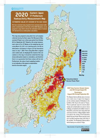
Starting from March 11, 2020, Minna-no Data Site will be offering free use of Map of Soil Radioactivity in 17 Prefectures in Eastern Japan at the time of the Tokyo Olympics
~The government of Japan has yet to conduct a wide range survey of soil radioactivity, but we did it and will offer free use of images of the results! You can use and modify the data for non-commercial use ~
Minna no Data Site (Everyone’s Data Site- Collective Database of Citizen’s Radioactivity Measuring Labs) will provide map data of “2020 Eastern Japan 17 Prefecture Radioactivity Measurement Map” (Japanese and English versions) free of charge with Creative Commons License (CC License) from March 11, 2020.
This map shows the estimated amount of radioactivity in the soil in the 17 prefectures of eastern Japan at the time of the July 2020 Summer Olympic Games, based on a calculation of how much the amount of radiation has decayed since initial soil radiation measurements were collected at 3400 locations in eastern Japan between 2014 to 2017.

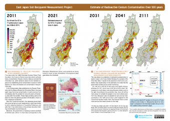
At the same time, we will also be allowing free use of “Estimate of Radioactive Cesium Contamination over 100 Years”Map.

—————————————————————-
■Why we are offering the free data
The torch relay of the Tokyo Olympic Games will start in Fukushima Prefecture on March 26. Because of this, homes of the evacuees along the route are scheduled to be dismantled by March 25. In addition, the national government (lead by he Nuclear Emergency Response Headquarters) and Fukushima Prefecture have recently agreed to partial cancellation of the “difficult to return-area” designation of some parts of Futaba-Town, Okuma-Town and Tomioka-Town, as if radioactive contamination has disappeared from these areas, when in fact the radiation levels there are still extremely high.
In addition, the torch relay route was approved despite the fact that the air dose of some places along the route are as high as 0.77 μSv/h. The reason behind this decision was that the torch bearers will “not stay there long.” Not only this air dose issue, surveys have also revealed that some locations along the route have soil radioactivity levels exceeding 1 million Bq/kg.
On the occasion of the 9th anniversary of the Great East Japan Earthquake that occurred on March 11, 2011, its commemorating events and vigils have been cancelled due to the recent coronavirus (Covid19) incident. As a result of considering what we could do facing this situation, we decided to release a map of soil radioactivity in the 17 prefectures of East Japan in July 2020 (downloadable version), in the response to many requests for the use of this map. We decided to provide the CC license (“Display — Noncommercial — Inherited”) in order to offer them free of charge.
—————————————————————-
■Difference from the past
Until now, it was not allowed to reprint or use this map without permission. From now on, anyone who meets the following conditions will be able to use the publicly available data without prior permission or application.
We also granted a CC license to “Estimate of Radioactive Cesium Contamination over 100 Years Map” free of charge.
—————————————————————-
■What is CC License?
By granting a CC license, authors are free to distribute their work while retaining their copyright, and recipients are free to redistribute, remix, etc., within the terms of the license.
1.Redistribution may be made by anyone for non-commercial purposes only, including “Minna no Data Site” and title credit of the map is mandatory.
2.Users can add their own data or information to this data and modify it to create new data.
3.Inclusion of the Creative Commons logo is a condition. Sources on the map cannot be deleted.
▼Available for download here
=>If you understand the “Use in accordance with Creative Commons requirements” above, check the box to go to the download page.。
I will use it according to the requirements of Creative Commons.
■What we expect for this action
This data is the fruit of the “East Japan Becquerel Measurement Project” conducted by citizens over a three year period from 2014 to 2017. It was then crowdfunded and self-published in November 2018. By providing free Japanese and English versions of some of the maps in the book at the same time, we will be able to create a base for the active use of the data collected by citizens in Japan, in hope that this information will be widely used by citizens and the media not only in Japan but also overseas to inform them of the actual situation of radioactive contamination caused by the Fukushima Daiichi Nuclear Power Plant accident.
See more.
—————————————————————-
■Outline of Group
Organization Name: Minna-no Data Site (Everyones’ Data Site)
Co-representatives: Hiromi Abe (NPO Fukushima 30-year Project), Shoko Onuma (Tokai No Nukes Network for Future Generations Citizens’ Radiation Measuring Center (C Lab.), Naoyuki Murakami (Agano Labo)
Address: 11 -7 Ipponmatsu, Iizaka-machi, Fukushima City, Fukushima Prefecture,
℅ NPO Fukushima 30-year Project 960 – 0201
Founded: September 2012
Outline of the organization:
A network of 31 citizen radioactivity measurement offices across Japan. Radioactivity measurement data of food and soil in each measurement room is consolidated into a single platform, and a website “Minna no Data Site” is operated so that anyone can easily search and browse it.
December 2017: Won the grand prize of the Information Distribution Promotion Award from Kazuo Hizumi.


