Categories
Ancient Image Quality Images on the Web Innovative Technology Museums VRC

The Digital Dead Sea Scrolls

The Google Cultural Institute and the Israel Museum, Jerusalem collaborated to bring five complete Dead Sea Scrolls online. The new digital library (released Tuesday, December 18), allows users to study and discover the the most ancient biblical manuscripts on earth:

The website gives searchable, fast-loading, high-resolution images of the scrolls, as well as short explanatory videos and background information on the texts and their history. The scroll text is also discoverable via web search. If you search for a phrase from the scrolls, a link to that text within the scroll may surface in your search results. For example, try searching on Google for [And the wolf shall dwell with the lamb Dead Sea Scroll].

English translations of the manuscripts are also available. The Google Cultural Institute is also responsible for the Art Project as well as other digital humanities projects, including Versailles 3D and La France en relief. For the Dead Sea Scrolls project, they used imaging technology originally developed for NASA. The scrolls weren’t discovered until 1947, and they had been in the Qumran caves for two thousand years. ArtDaily reports:

The parchment and papyrus scrolls contain Hebrew, Greek and Aramaic script, and include several of the earliest-known texts from the Bible, including the oldest surviving copy of the Ten Commandments. The oldest of the documents dates to the third century BC and the most recent to about 70 AD, when Roman troops destroyed the Second Jewish Temple in Jerusalem. The artefacts are housed at the Israel Museum in Jerusalem, where the larger pieces are shown at the dimly lit Shrine of the Book on a rotational basis in order to minimise damage from exposure. When not on show, they are kept in a dark, climate-controlled storeroom in conditions similar to those in the Qumran caves, where the humidity, temperature and darkness preserved the scrolls for two millennia.

For more information, visit the Digital Dead Sea Scrolls.

Via artdaily.org

Categories
Innovative Technology Museums

Harvard Archaeologists Use 3D-Printing to Repair Ancient Artiacts

Two archaeologists at Harvard University’s Semitic Museum have begun using 3D-scanning and 3D printing to repair a ceramic artifact that was partially destroyed 3,000 years ago during an attack by the Assyrian army. They envision that this kind of work will be useful for conservation, research, and teaching purposes. The archaeologists describe their project:

Using a process called photomodeling, the Harvard team photographed sculpture fragments in the museum’s collection from hundreds of angles to create 3-D renderings of each piece, then meshed them together to form a semi-complete 3-D model of the original artifact. They compared the digital model to scans of full statues found in the same location, noting the gaps and creating the missing pieces and support structures out of 3-D printed parts and CNC carved foam. The technique worked successfully: The reconstituted sculpture will be displayed at the museum when this gallery is reinstated in 2014-15, but will likely be online well before that.

Via Wired

Categories
Innovative Technology

Local/Global: Mapping Nineteenth-Century London’s Art Market

The online art journal Nineteenth Century Art Worldwide recently featured a new digital humanities research project that focuses on London’s art market from 1850–1914. The researchers aim to document the rise and spread of commercial galleries across the city by aggregating data from a variety of sources including galleries, exhibition societies, artists’ addresses, and retail spaces. The data was then added to a map of Victorian London—users can turn data on or off depending on their research, including moving chronologically through time.

Pamela Fletcher and Anne Helmreich describe the project and offer their own conclusions based on their research in Nineteenth Century Art Worldwide, and the London Gallery Market website with their maps and data is freely available.

Via Nineteenth Century Art Worldwide and London Gallery Market

Image: Pamela Fletcher and David Israel, London Gallery Project, 2007, revised 2012.

Categories
Images on the Web Innovative Technology VRC

BnF Launches new Gallica iPad App

The Bibliothéque Nationale de France recently released an iPad app for their digital library Gallica. The app, also called Gallica, contains nearly 2 million freely available items from the BnF, including books, journals, manuscripts, photographs, prints, posters, cards, and music scores among many others.

The app allows you to search or browse through all digitized material available through the BnF, and each document can be viewed in its entirety. You can create a favorites list, view the full bibliographic record, download entire documents or individual pages, email links, or share the object on social media outlets including Facebook and Twitter.

You can download the app here, or stop by the VRC to check it out on our iPad!

Categories
East Asian Images on the Web

The Tibetan and Himalayan Library Image Collections

The Tibetan and Himalayan Library (THL) collections of images are indexed by THL’s Place Dictionary and Knowledge Maps for easy exploration. View over 60,000 photos of Tibet and the Himalayas, many with links to maps.

The Tibetan and Himalayan Library is a publisher of websites, information services, and networking facilities relating to the Tibetan plateau and southern Himalayan regions. THL promotes the integration of knowledge and community across the divides of academic disciplines, the historical and the contemporary, the religious and the secular, the global and the local.

Images are linked together by topic, location, and collection for easy browsing and context. For more information, see the library’s main site.


Categories
Innovative Technology

Innovative GIS Projects in the Humanities

Below is a list of humanities-related Geographic Information System projects and their potential applications. Do you know of another exciting project to add to the list? Please let us know!

Project list compiled by VRC staff member Helenmary Sheridan.

Google Lit Trips

http://www.googlelittrips.com/GoogleLit/Home.html

Developer: Various contributors; Jerome Burg, site editor

Discipline: Literature

(View of the “A Portrait of the Artist As a Young Man” Lit Trip, by David Herring)

(“The Grapes of Wrath” Lit Trip in Google Earth, by Jerome Burg)

What it does: Contributors have mapped the journeys of fictional characters on modern and historical maps supplied by Google in Google Maps and Google Earth. These maps can be saved and shared, along with accompanying text and images that also use Google-supplied tools. Routes can cross a single city or whole continents, and users who have downloaded multiple datasets can compare journeys.

How it does it: Google Maps, Google Earth

What this could be adapted for: This is itself an adaptation of a familiar use of GIS. Similar projects could follow the movement of an artist on the Grand Tour, a specific artwork from collection to collection, or a book from its author to printer to eventual reader.

Mapping the Republic of Letters

https://republicofletters.stanford.edu/

Developer: Dan Edelstein and Paula Findlen, Stanford Humanities Center

Discipline: Literature, History

What it does: The Republic of Letters project maps the physical locations of 6,400 correspondents from 1629 to 1824 and the routes of 55,000 letters and documents exchanged among them. A histogram reveals that the 1760s were peak years for the correspondence recorded in the Electronic Enlightenment database; London and Paris were the top cities of correspondence, and Voltaire, Rousseau, and Locke were the top three letter-writers of the entire period (though Voltaire received very few in return.) The map can display connections between correspondents, city-dots by correspondence volume, routes marked according to their traffic frequency, and a writer vs. writer comparison view. Users can also filter the data by correspondent, choosing between sender or receiver. Finally, data periods on the histogram are adjustable, and a play button allows the user to move through time year-by-year.

How it does it: Probably visualization software and staff-developed tools. A much rougher tool along the same lines could be made with ArcGIS, which is used at the University of Chicago.

What this could be adapted for: Correspondence of any time and place, or exchanges of sketches, trade routes, any other documented physical object; which contemporaries authors cite in their manuscripts, the dissemination of news stories, who marries whom in dynastic marriages…

The Map of Early London

http://mapoflondon.uvic.ca/experimental_map.php

Developer: Janelle Jenstad, University of Victoria

Discipline: History/Humanities (English literature)

What it does: Toggle-controlled layers displaying roads, building names, ward boundaries, and other points of interest from the late sixteenth to early seventeenth centuries are built on top of the 1560s Agas map. Querying a site will load information about it in a separate window, either a modern history and description or a transcription from contemporary sources that reference it.

How it does it: The map was built with ka-map, which allows for selectable layers, legends, zooming, and panning. Both the original, non-layered map and the more complicated “experimental” version are several years old.

What this could be adapted for: This sort of map/layer/content setup is ideal for connecting texts or images to specific locations, though probably most useful in a limited geographic context like a city. The Map of Early London points out Shakespeare’s theatres and places important to Renaissance drama, but a similar map could go further and build layers associating printers’ shops with particular writers, grouping contemporary performances together in a layer separate from performances a decade later, or go in a non-theatrical direction and study artist-client relationships within Florence, for example, and the network of tradesmen who supplied the artists.

Digital Atlas of Roman and Medieval Civilization

http://darmc.harvard.edu/icb/icb.do?keyword=k40248&tabgroupid=icb.tabgroup53584

Developer: Michael McCormick and Guoping Huang, Harvard University

Discipline: Archaeology/History

What it does: The atlas compiles a huge amount of information about Roman and medieval sites throughout Europe, the Near East, and North Africa from archaeology and literature, then presents them in an interface. Cities are color-coded according to certainty about their location, but not sorted according to era or culture; though the user can view overlays of kingdoms at the same time, it’s not possible to drag layers so that one overlays the other. Querying points brings up identification, labels visible only at maximum zoom.

How it does it: ArcGIS, the same software used on the University of Chicago campus.

What this could be adapted for: Any sort of atlas project with various sources of data displayed at once.

The Geography of Art: Imaging the Abstract with GIS

http://www.directionsmag.com/features.php?feature_id=44

Developer: Jim Coddington, MoMA

Discipline: Art History

What it does: Coddington’s team adapted imaging techniques usually used in GIS to photograph terrain, instead turning it on a Pollock canvas to photograph paint clusters and specific pigments that can be distinguished with multi-spectral imaging. Their results, while preliminary, show that GIS techniques can successfully isolate paint based on texture, pigment, or location, characteristics sometimes invisible to the naked eye or to other imaging techniques. Though Coddington does not discuss this aspect, their integration of GIS imaging and atwork also raises the possibility of treating a canvas itself like a map, placing features of a painting on a sort of coordinate grid and then drawing spatial relationships between them.

How it does it: Multispectral imaging and mosaic software.

What this could be adapted for: The imaging technique is applied here uniquely to art history, but the idea of georeferencing locations on an artwork could be applied to the printed page as an alternative to conventional hypertext. Within art history, underdrawings and a final painting could be distinct layers on a “map” of the artwork, with location labels providing more information on technique or any element of interest. Or, using a Pollock as an example, the georeferenced location of paint globs could lead to a model of the artist’s hand movement.

 

Categories
Photography

Photographing Archival Materials

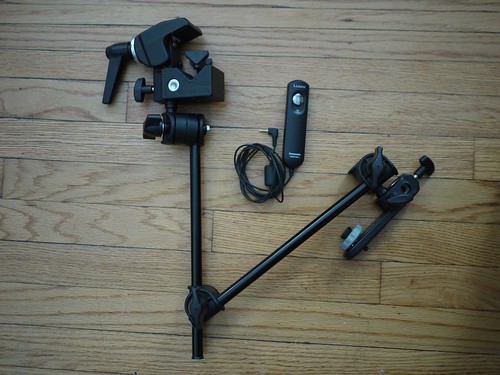
Before embarking on a research trip, you might prepare to photograph materials in libraries and archives. It can be difficult to capture quality images of archival materials, especially in low-light situations. A recent guest post on ProfHacker details one way of stabilizing a digital camera, which includes using a clamp, articulated arm and wired camera remote as a sort of portable copy stand.

Keep in mind that some of the processes advocated in the article will not be allowed in all archives or libraries. Check with archives, museums or libraries before your visit to ask about policies; most will have specific requirements for equipment used in reading rooms. If you have questions about cameras or other photography best practices, please contact the VRC.

Via Derivative Image.

Categories
Innovative Technology VRC

Highlighting the Digital Humanities

The article “Digital Keys for Unlocking the Humanities’ Riches” recently published in the New York Times discusses the growing importance of data and technology to research in the humanities.

The next big idea in language, history and the arts? Data.

The focus on digital humanities is timely; this weekend the Visual Resources Center and the Division of the Humanities are co-sponsoring, along with the Newberry Library and Northwestern University, the very first THATCamp Chicago. THATCamp Chicago is a user-generated “unconference” where humanists and technologists work together for the common good. For more information, click here.

See also the University of Chicago Press’ recent blog entry exploring the top five recent books about new methodologies in the digital humanities.

Categories
Innovative Technology Software

TechTalk: Geospatial Tools for Humanities Research

Please join us this Thursday (4/15, 12pm, Rosenwald 405) for a lunchtime TechTalk on “Geospatial Tools for Humanities Research.”

Geographic Information Systems (GIS) are powerful tools which combine current information with historical and modern maps for analytic and presentation purposes. VRC student staff member Helen-Mary Sheridan will present an overview of fundamental GIS concepts and present a range of current examples of their use in the humanities, including annotated atlases, a map for tracking geospatial components in literary collections, and (geo)spatial analyses of paintings.

Humanities Computing TechTalks are informal, brown bag style events for learning more about current technology topics relevant to the humanities. TechTalks are free and open to all university faculty, staff and students.

For a current list of future TechTalks, please goto the Humanities Division events calendar and search by sponsor “Computing.”