Mayor of Namie invites Google’s cameras in to stop world forgetting twin disasters of tsunami then nuclear meltdown
[…]
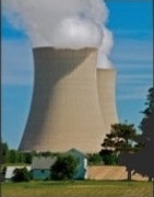
Google Street View has published striking images of the devastation visited on Namie by the March 2011 tsunami and nuclear meltdown: abandoned homes, shops and restaurants, fields blanketed in grass and weeds.
Google’s camera-equipped vehicles began filming in Namie this month at the invitation of its mayor, Tamotsu Baba, whose sadness at his town’s fate is matched by fears that the rest of the world is forgetting about Fukushima.
For residents from towns and villages near the crippled power plant, the crisis is far from over. About 160,000 who fled the 12-mile evacuation zone, including 21,000 from Namie, are still living in temporary housing.
Those from areas closest to the site may have to wait decades before their irradiated communities are safe to live in again. Many older residents accept they will die before their homes are inhabitable; their younger relatives are trying to build new lives elsewhere.
Google’s Street View imagery takes users on a 360-degree virtual tour of Namie’s eerily quiet streets, its earthquake-damaged buildings and the overturned cars and fishing boats resting where they were deposited by the tsunami.
Read more at Fukushima town revealed in Google Street View two years after tsunami